


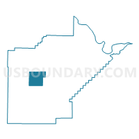
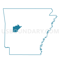
Herring Voting District, Yell County, Arkansas
About
Outline

Summary
| Unique Area Identifier | 528567 |
| Name | Herring Voting District |
| County | Yell County |
| State | Arkansas |
| Area (square miles) | 27.17 |
| Land Area (square miles) | 27.15 |
| Water Area (square miles) | 0.01 |
| % of Land Area | 99.95 |
| % of Water Area | 0.05 |
| Latitude of the Internal Point | 34.98868990 |
| Longtitude of the Internal Point | -93.51813140 |
Maps

Graphs
Select a template below for downloading or customizing gragh for Herring Voting District, Yell County, Arkansas


Neighbors
Neighoring Voting District (by Name) Neighboring Voting District on the Map
- Bluffton Voting District, Yell County, AR
- Briggsville Voting District, Yell County, AR
- Compton Voting District, Yell County, AR
- Danville Voting District, Yell County, AR
- Dutch Creek Voting District, Yell County, AR
- Ferguson Voting District, Yell County, AR
- Rover Voting District, Yell County, AR
Top 10 Neighboring County Subdivision (by Population) Neighboring County Subdivision on the Map
- Danville township, Yell County, AR (2,882)
- Ferguson township, Yell County, AR (1,373)
- Herring township, Yell County, AR (188)
- Bluffton township, Yell County, AR (160)
- Briggsville township, Yell County, AR (128)
- Dutch Creek township, Yell County, AR (109)
- Compton township, Yell County, AR (94)
Top 10 Neighboring Unified School District (by Population) Neighboring Unified School District on the Map
- Two Rivers School District, AR (7,182)
- Danville School District, AR (4,047)
- Western Yell County School District, AR (2,775)